CTC Alpine Profile Road Book 1910
Edited by R. H. U. Ellis191065 chapters102 images
Contents
- Explains the book's origin in the author's own touring notes, checked by aneroid, cyclometer and revolution counter over several seasons including an extended 1909 tour, and compiled into diagrams giving distances, altitudes and gradients in both metric and English measures with the vertical scale exaggerated ten-to-one for clarity.
- Sets out four sample itineraries: a fortnight in south-west Switzerland via Zermatt, Chamonix, the Grimsel and Brunig passes; a fortnight in south-east Switzerland including the Stelvio and optionally the Splugen; a fortnight in the Tyrol via the Stelvio, Tonale, Karer and Falzarego passes to Cortina and Innsbruck; and a longer three-to-four-week tour combining Switzerland, the Tyrol and North Italy via the Susten, Gemmi, Simplon, San Bernardino and Julier passes.
- Describes Les Mosses Pass between Aigle and Chateau d'Oex, reached by a steep, dusty climb from Aigle to Sepey with fine scenery, and the Saanen Moser Pass beyond Chateau d'Oex, which has a fine surface and a long downhill run from Saanen to the Lake of Thun.
- Describes the low (about 3,300 ft) Brunig Pass between Thun and Lucerne, prized for charming scenery and exhilarating coasting on the smooth north-side surface at speeds up to twenty-five miles an hour, with a rack railway available for the ascent.
- Describes the Gemmi Pass, a mule path rather than a carriage road linking Kandersteg to Loeche-les-Bains, rideable by bicycle with a hired porter over the roughest sections; details the stage-by-stage climb past the inn 'beim Stock' and the Daubensee to the summit hotel, then the steep zigzag descent.
- Describes the newly built Klausen Pass carriage road, best ridden from Linthal towards Altdorf via two series of zigzags past Urnerboden, with fine views of the Clariden and the Uri mountains and a well-engineered, exciting descent to Altdorf.
- A one-line note on the Oberalp Pass warning of very bad surface on the steep sections at either end of the Chur-Andermatt road.
- Describes the stiff, nearly 3,000-foot climb from Realp to the Furka Pass summit, rewarded by views of the Matterhorn, Monte Rosa and the Rhone Glacier, followed by a very steep, poor-surfaced descent to Gletsch and on towards Brieg.
- Describes the very steep Col de la Forclaz (nearly 650 ft per mile from the Martigny side) on the Martigny-Chamonix road, and the neighbouring Col des Montets with its sudden view of the Mont Blanc chain and a steep zigzag drop to Argentiere.
- Defends the St Gotthard Pass's ascent from Airolo against a published complaint of tedium, describing the increasingly fine mountain views and the engineering interest of the Val Tremola zigzags, and advises taking the road rather than the tunnel.
- Describes the San Bernardino Pass from Bellinzona, recommending the electric railway from Bellinzona to Mesocco to save the first climb, then details the zigzag stages past San Giacomo and Lago d'Osso to the summit hospice and the steep drop to Hinter-Rhein and Splugen village.
- Praises the Grimsel Pass between Gletsch and Meiringen for unsurpassed scenery, describing the steep 1,300-foot zigzag climb from Gletsch, the view of the Grimsel Hospice by its lake, and the gorge-side descent past the Handegg Fall to Innertkirchen.
- Describes the Simplon Pass between Brieg and Domodossola, noting the 1909 dust and remetalling works on the Italian side and recommending the pass be avoided until the surface recovers, alongside praise for the deep Gorge of Gondo.
- Describes the Finero Pass as a pleasant, shorter alternative to the Pallanza road between Domodossola and Cannobio, climbing from Masera past Druogno and Santa Maria Maggiore before a steep zigzag drop into the Val Cannobina.
- Calls the Splugen Pass, approached from Thusis via the Via Mala, second only to the Stelvio, describing its parallel zigzag terraces, long protective snow galleries, the 650-foot waterfall near Pianazzo, and the thrilling descent to Campo Dolcino and Chiavenna.
- Recommends taking the Maloja Pass downhill from the Engadine, describing the very steep final one-and-three-quarter miles of zigzags up through woods from Chiavenna and the fine view down the Val Bregaglia from the summit seats.
- Describes the Julier Pass from Tiefenkastel via Muhlen and Bivio with its steep zigzag final stage and Engadine views, and the short but scenically outstanding Schyn Pass linking Tiefenkastel and Thusis, best seen when travelling from Thusis.
- Describes the Bernina Pass as easy on the Swiss (Engadine) side, mostly rideable uphill by a strong rider, but almost entirely unrideable on the steeper Italian side towards Tirano, noting the electric railway then nearing completion over the summit.
- Describes the Albula Pass from Ponte to Tiefenkastel, best ridden south-east to north-west for the superb Engadine views and the engineering marvels of the Albula Railway near Bergun, and the onward Parpan Pass to Chur, whose final descent from Malix was very rough and stony as of 1907.
- Gives a carefully re-measured profile of the Fluela Pass from Davos past the Alpenrose Inn and Tschuggen to the summit hospice, with a steep, loose descent to Suss, especially the final two miles.
- Calls the Ofen Pass one of the least repaying passes, monotonous especially in its eastern half, useful chiefly as a shortcut from Zernetz to Schluderns or, with the Umbrail Pass, towards the Stelvio, though rarely worth the detour.
- Describes the Umbrail Pass as one of the stiffest climbs in the region, rising nearly 4,000 feet in eight miles from Santa Maria in Munstertal to the Stelvio road, on a good surface but exceedingly trying gradient.
- Extols the 9,050-foot Stelvio Pass, the highest road pass in Europe, as the 'Mecca' of Alpine cycle touring, detailing the walk-heavy climb from Prad through Gomagoi and Trafoi to Franzenshohe and the summit, and the nearly unbroken forty-mile coast down the Italian side to Bormio through the Diroccamento Defile's galleries and tunnels.
- Describes the Aprica Pass from Tresenda past the Belvedere Inn to Edolo, and the comparatively easy Tonale Pass beyond Ponte di Legno, both with fine scenery and mostly good surfaces, connecting through to Fucine and the Presanella group.
- Describes the Karer Pass, the first stage of the new Dolomitenstrasse from Bozen, noting the hot, narrow gorge to Kardaun, the poor dusty surface for the first climbing miles, and the improving road past the Karersee to the summit hotel with views of the Rosengarten and Latemar.
- Describes the second and third stages of the Dolomitenstrasse: the well-engineered, terraced Pordoi Pass from Canazei with its figure-of-eight descent to Araba, and the Falzarego Pass beyond Andraz past the ruins of Castell Andraz to a Dolomite panorama, both praised as triumphs of Austrian road engineering.
- Describes the trying Campo di Carlo Magno ascent from Dimaro to Pinzolo, a monotonously steep five-mile zigzag climb at 400 feet per mile followed by a dangerously steep, narrow final drop to Madonna di Campiglio.
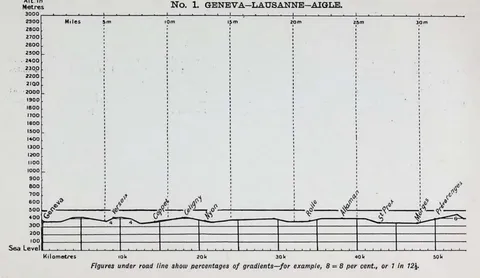
- Profile and distance table for the lakeside road from Geneva through Nyon, Morges, Lausanne and Vevey to Aigle, noted for its magnificent surface, easy gradients and views across the Lake of Geneva.
- Profile and table for an alternative, very steep route from Le Sepey over the Col de Pillon to Saanen, offered as a variant to the Les Mosses Pass road though with less interesting scenery.
- Short, level profile and table for the road down the Rhone valley from Aigle via St. Maurice to Martigny, described as a magnificent level road.
- Profile and table for the nearly level road along the south side of Lake Thun from Erlenbach via Spiez and Darligen to Interlaken.
- Profile and table for a side trip from Frutigen up to Adelboden, described as steep in parts with a fair proportion rideable but very bad in wet weather.
- Profile and table for the loop from Interlaken via Lauterbrunnen and the Wengern Alp to Little Scheidegg and Grindelwald and back, largely a pedestrian route with bicycles sent ahead by train, noting care needed on the dusty zigzags at Burglauenen.
- Profile and table for the road from Glarus via Mollis, Walenstadt and Sargans to Chur, mostly in good condition though dusty in parts, with a note that the climb to Filsbach can be avoided by rail from Mollis to Muhlehorn.
- Short spur route and table linking Mollis to Weesen, used as an alternative link on the Glarus-Chur road.
- Profile and table for the road from Chamonix via Le Fayet, Cluses and Bonneville to Geneva, described as a very good road and an easy ride with an almost continuous drop to Cluses.
- Profile and table for the second-class road over the Lukmanier Pass from Disentis via Olivone to Biasca and Bellinzona, steep near Curaglia and again near Olivone and Acquarossa.
- Profile and table for the spur from Visp to Zermatt via Stalden and St Niklaus, a rough foot track for the first nine miles best covered by train to St Niklaus before a fair but narrow road continues to Zermatt.
- Profile and table for the very good, dusty level road along Lake Maggiore from Domodossola via Pallanza, Cannobio and Locarno to Bellinzona.
- Profile and table for the road from Baveno along Lake Maggiore through Biella and over the Serra Pass to Ivrea and Verres, warning of a strong prevailing wind blowing from Ivrea towards Aosta.
- Profile and table for the very good but exceedingly steep Great St Bernard Pass road from Verres through Aosta and Etroubles to the hospice and down through Bourg St Pierre and Orsieres to Martigny, recommending an overnight stay at the hospice.
- Short profile and table for the fair, level road linking Gera to Bellinzona via Cadenazzo.
- Profile and table for the road from Bellinzona over the Monte Cenere Pass to Lugano, a stiff climb to the summit followed by a good run down.
- Profile and table for the very good road with zigzags to Croce linking Menaggio to Lugano via Porlezza, the final stretch to Lugano covered by boat.
- Profile and table for the good road from Lugano via Ponte Tresa to Luino on Lake Maggiore.
- Profile and table for the good, mostly level road from Santa Agata via Colico to Varenna on Lake Como, continuing to Menaggio by boat.
- Profile and table for the good undulating road along the western shore of Lake Como from Santa Agata through Sorico and Gravedona to Menaggio.
- Profile and table for the almost dead-level but hot Valtellina valley road from Tresenda via Sondrio and Morbegno to Santa Agata, with a note that the train is preferable.
- Profile and table for the excellent and interesting Lower Engadine road from Ardetz (Ardez) via Schuls and Martinsbruck to Nauders.
- Gives two short alternative links in the Lower Engadine - Ardetz to Schuls via Ftan, and Schuls to Crusch via Sent - noting the main road of the Ardetz-Nauders route is generally better but that Sent is a charmingly situated village.
- Short profile and table for the excellent descending road from Tirano via Madonna di Tirano to Tresenda in the Valtellina.
- Profile and table for the fair-to-very-good, exceedingly picturesque Landwasser road from Tiefenkastel to Davos.
- Profile and table for the magnificent-surfaced road from Landeck via Nauders and Mals to Neu Spondinig, continuing on a very steep, narrow road with dangerous zigzags up to Sulden.
- Profile and table for the very good road over the comparatively easy Mendel Pass from Mostizoll Brucke via Fondo to San Michele and Bozen.
- Profile and table for the good road with fine views over the Campolungo Pass from Araba via Corvara and Pedratsches to St Lorenzen, offered as an alternative link towards Toblach.
- Profile and table for the very poor, hot and dusty valley road from Neu Spondinig via Latsch and Meran to Bozen, with the train recommended instead, especially southbound.
- Short profile and table for the fair road from Mostizoll Brucke via Cles and Taio to San Michele.
- Profile and table for the good, almost level but very hot road from Bozen via Neumarkt and San Michele to Trent.
- Profile and table for the very good, gently falling main road from Cortina d'Ampezzo via Longarone and Belluno to Feltre.
- Profile and table for the good undulating road from Feltre through Primolano, Levico and Trent to Alle Sarche, described as scenically interesting but not mountainous.
- Profile and table for the splendid-surfaced, comparatively easy Brenner Pass road from Innsbruck via Steinach and Gossensass to Franzensfeste and Klausen, noting the climb can be avoided by rail.
- Short profile and table for the very good, mostly descending main road from Klausen via Atzwang and Kardaun to Bozen.
- Profile and table for the very fine, falling-gradient road from Toblach via Welsberg and Bruneck to St Lorenzen and Franzensfeste, described as delightful though lacking grandeur.
- Profile and table for the very good but hilly and tiring road along the Inn valley from Innsbruck via Telfs and Imst to Landeck and on to Pettneu.
- Profile and table for the very good, scenic Arlberg Pass road from Pettneu via St Anton to Klosterle, Bludenz and Feldkirch, continuing through Vaduz to Sargans, noting the pass may be bypassed via the Arlberg rail tunnel.
Images in this book 102 pictures from 156 pages
Illustrations 2
 (opens in a new tab)
 Alpine Profile Road Book  (opens in a new tab)
 Cyclists' Touring Club
Maps 2
 (opens in a new tab)
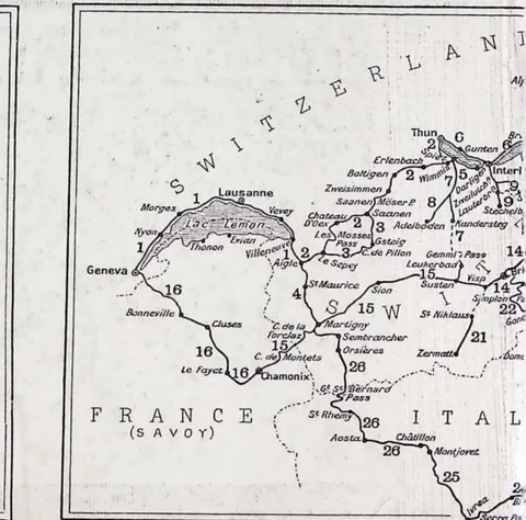
 Key Map of Routes 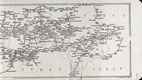 (opens in a new tab)
 Alpine Routes Map
Diagrams 98
 (opens in a new tab)
 No. 1. Geneva…Lausanne…Aigle 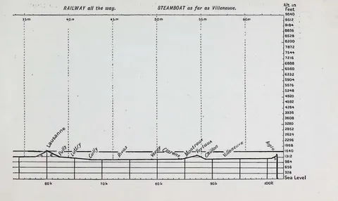 (opens in a new tab)
 Railway and Steamboat Routes 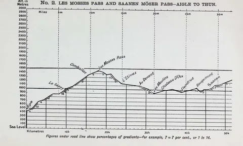 (opens in a new tab)
 No. 2. Les Mosses Pass and Saanen Möser Pass…Aigle to Thun 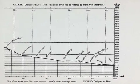 (opens in a new tab)
 Railway and Steamboat Options 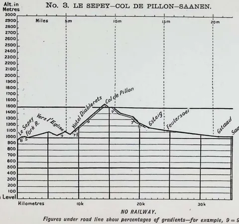 (opens in a new tab)
 No. 3. Le Sepey…Col de Pillon…Saanen 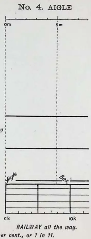 (opens in a new tab)
 No. 4. Aigle 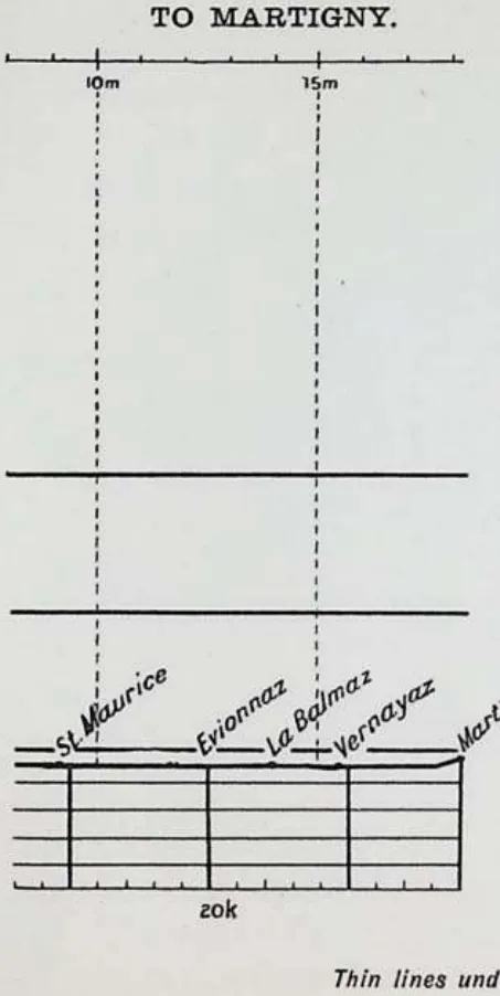 (opens in a new tab)
 To Martigny 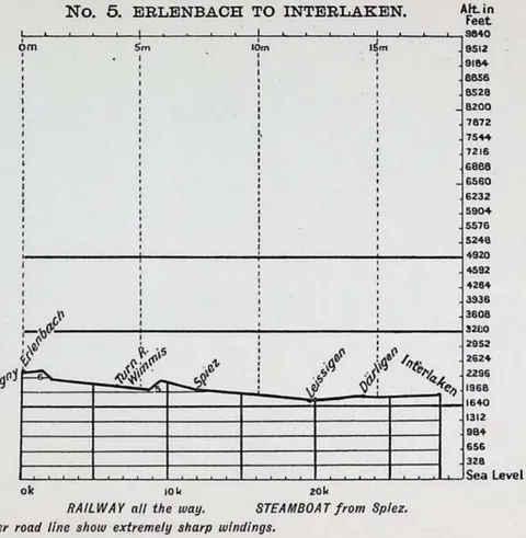 (opens in a new tab)
 No. 5. Erlenbach to Interlaken 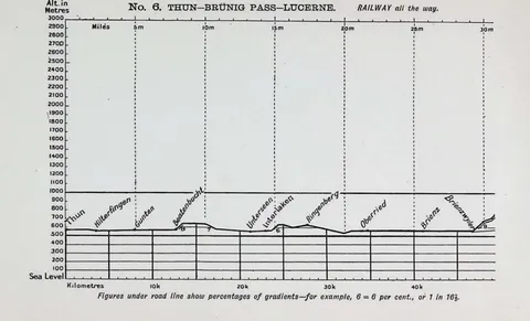 (opens in a new tab)
 No. 6. Theun…Brunig Pass…Lucerne 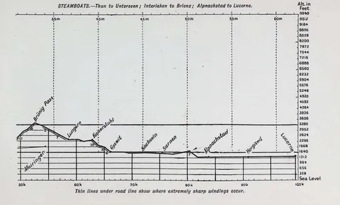 (opens in a new tab)
 Steamboat Routes 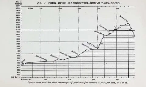 (opens in a new tab)
 No. 7. Thun…Spiez…Kandersteg…Gemmi Pass…Brieg 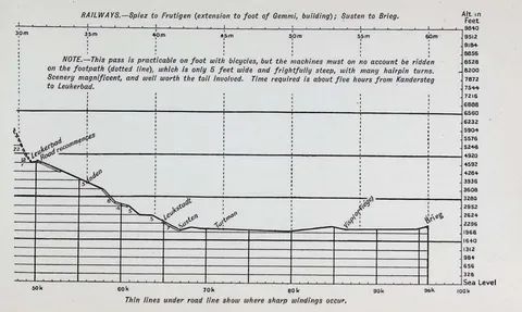 (opens in a new tab)
 Railway Routes to Leukerbad 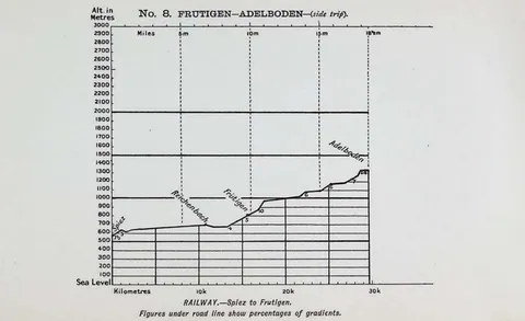 (opens in a new tab)
 No. 8. Frutigen…Adelboden (side trip) 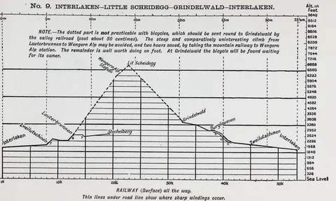 (opens in a new tab)
 No. 9. Interlaken…Little Scheidegg…Grindelwald…Interlaken 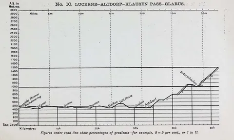 (opens in a new tab)
 No. 10 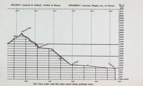 (opens in a new tab)
 Route 10 Alternative 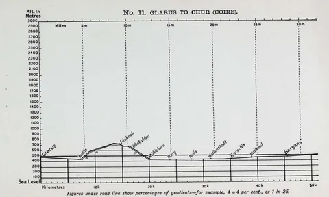 (opens in a new tab)
 No. 11. Glarus to Chur (Coire) 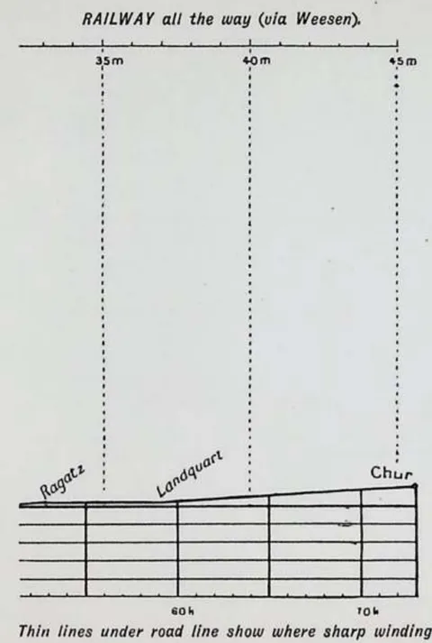 (opens in a new tab)
 Railway all the way (via Weesen) 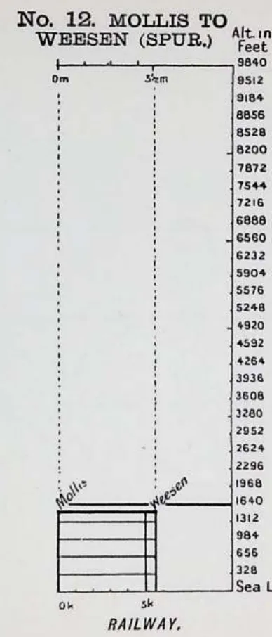 (opens in a new tab)
 No. 12. Mollis to Wreesen (Spur) 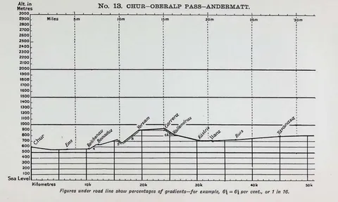 (opens in a new tab)
 No. 13 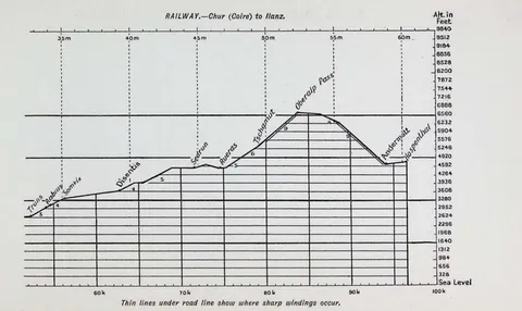 (opens in a new tab)
 Route 13 Alternative 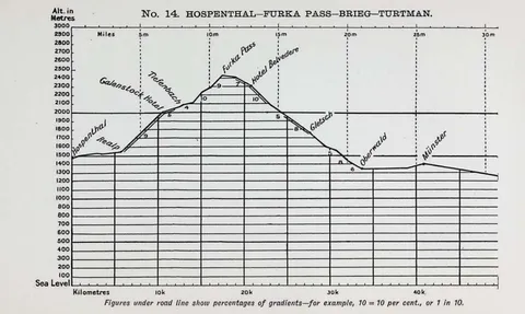 (opens in a new tab)
 No. 14 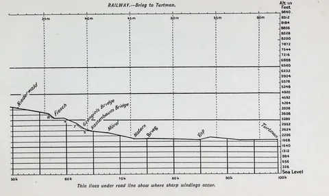 (opens in a new tab)
 Railway…Brieg to Turtman 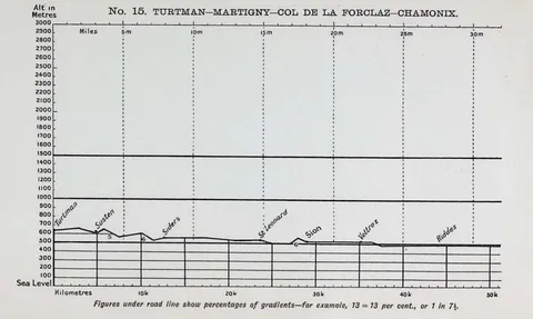 (opens in a new tab)
 No. 15 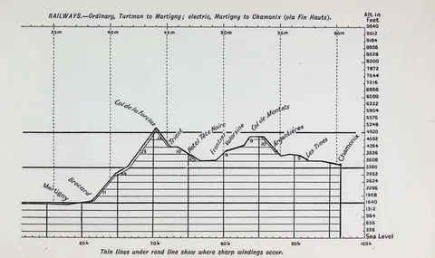 (opens in a new tab)
 Route 15 Alternative 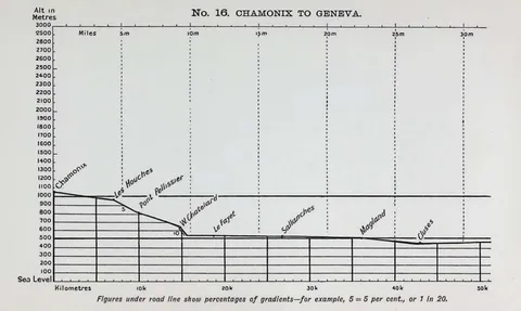 (opens in a new tab)
 No. 16 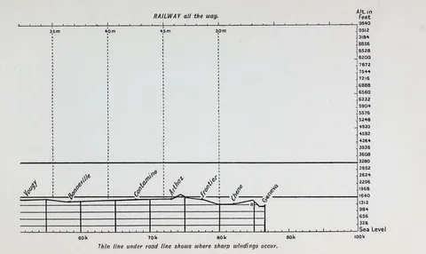 (opens in a new tab)
 Route 16 Alternative 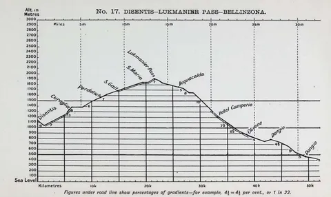 (opens in a new tab)
 No. 17. Disentis…Lukmanier Pass…Bellinzona 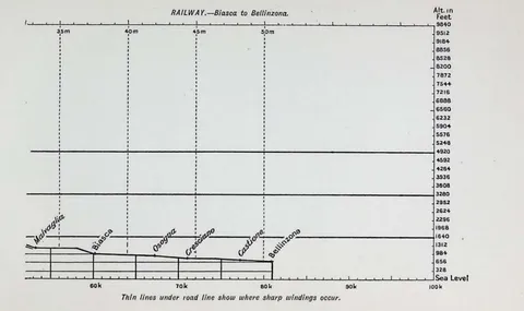 (opens in a new tab)
 Route 17 Alternative 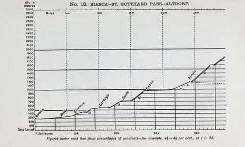 (opens in a new tab)
 No. 18 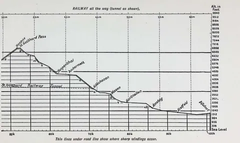 (opens in a new tab)
 Route 18 Alternative 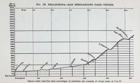 (opens in a new tab)
 No. 19 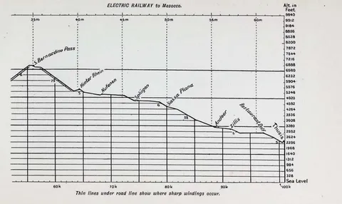 (opens in a new tab)
 Electric Railway to Mesocco 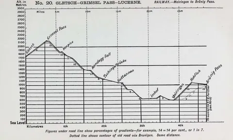 (opens in a new tab)
 No. 20 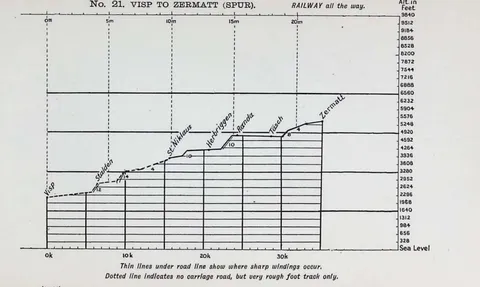 (opens in a new tab)
 Route 20 Alternative 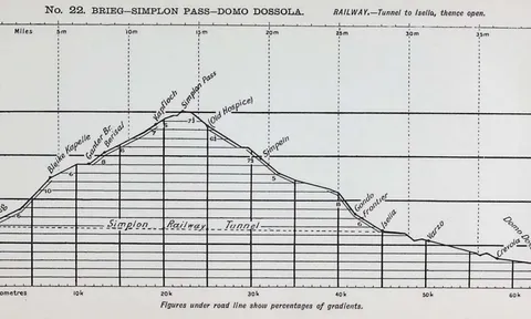 (opens in a new tab)
 No. 21 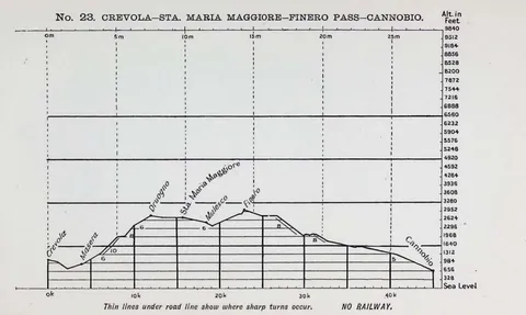 (opens in a new tab)
 Route 21 Alternative 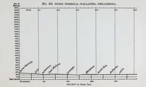 (opens in a new tab)
 No. 24. Domo Dossola…Pallanza…Bellinzona 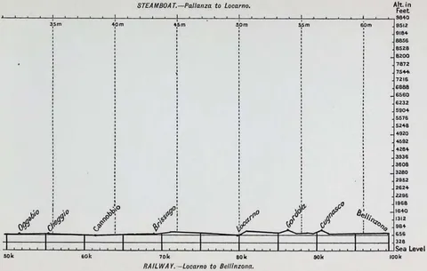 (opens in a new tab)
 STEAMBOAT.…Pallanza to Locarno. RAILWAY.…Locarno to Bellinzona. 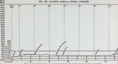 (opens in a new tab)
 No. 25. BAVENO-BIELLA-IVREA-VERREX. 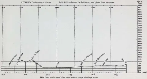 (opens in a new tab)
 STEAMBOAT.…Baveno to Arona. RAILWAY.…Baveno to Gattinara, and from Ivrea onwards. 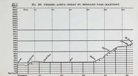 (opens in a new tab)
 No. 26. VERREX…AOSTA…GREAT ST. BERNARD PASS…MARTIGNY. 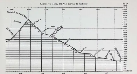 (opens in a new tab)
 RAILWAY to Aosta, and from Orsières to Martigny. 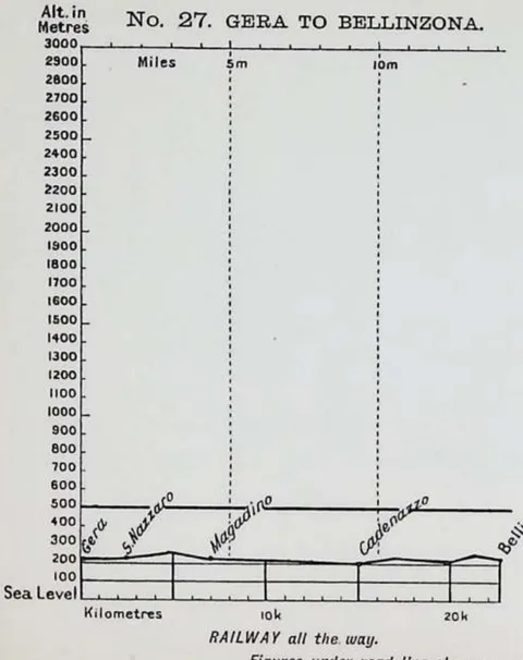 (opens in a new tab)
 No. 27. GERA TO BELLINZONA. 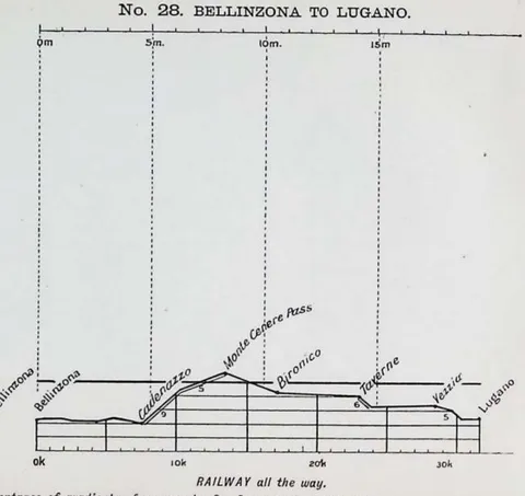 (opens in a new tab)
 No. 28. BELLINZONA TO LUGANO. 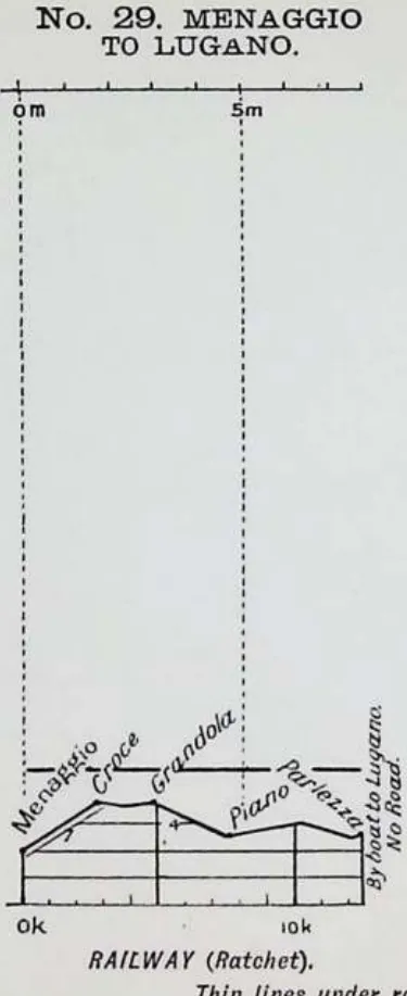 (opens in a new tab)
 No. 29. MENAGGIO TO LUGANO. 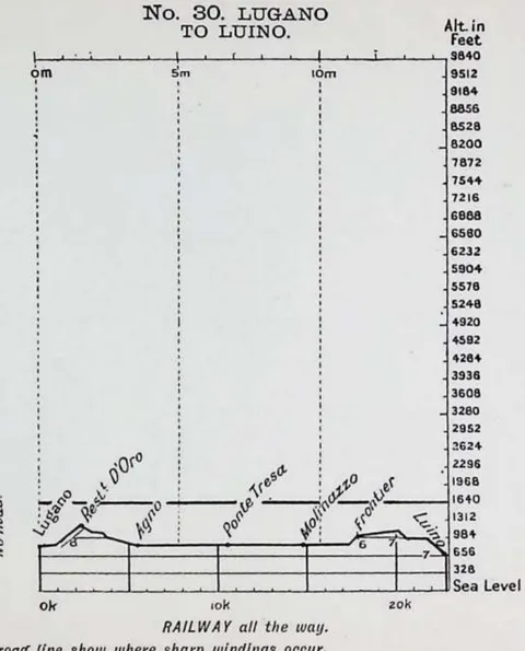 (opens in a new tab)
 No. 30. LUGANO TO LUINO. 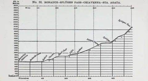 (opens in a new tab)
 No. 31. BONADUZ…SPLÜGEN PASS…CHIAVENNA…STA. AGATA. 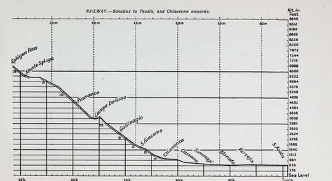 (opens in a new tab)
 RAILWAY.…Bonaduz to Thusis, and Chiavenna onwards. 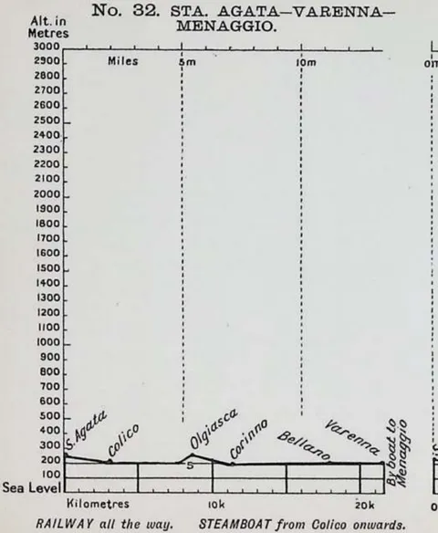 (opens in a new tab)
 No. 32. STA. AGATA…VARENNA…MENAGGIO. 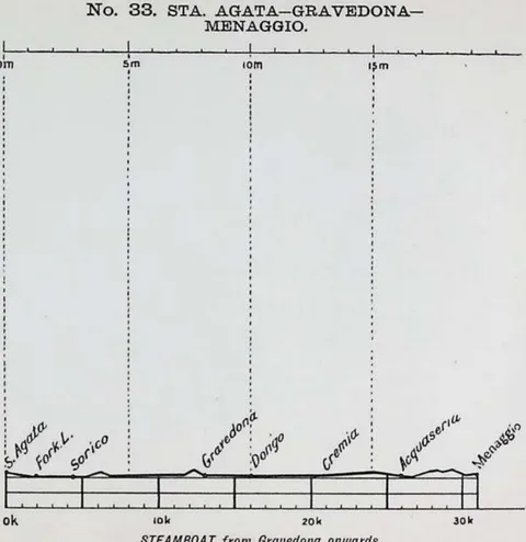 (opens in a new tab)
 No. 33. STA. AGATA…GRAVEDONA…MENAGGIO. 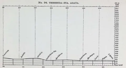 (opens in a new tab)
 No. 34. TRESENDA…STA. AGATA. 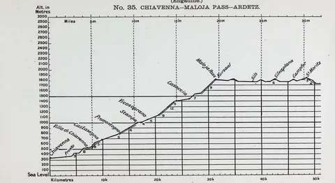 (opens in a new tab)
 (Engadine.) No. 35. CHIAVENNA…MALOJA PASS…ARDETZ. 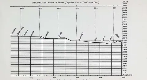 (opens in a new tab)
 RAILWAY.…St. Moritz to Bevers (Engadine line to Thusis and Chur). 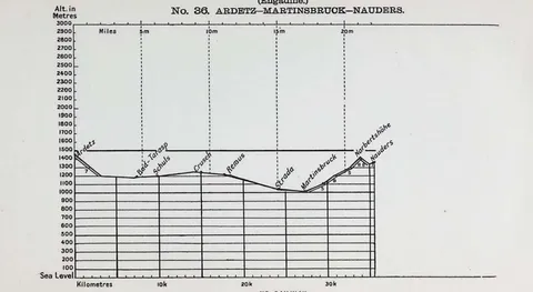 (opens in a new tab)
 (Engadine.) No. 36. ARDETZ…MARTINSBRUOK…NAUDERS. 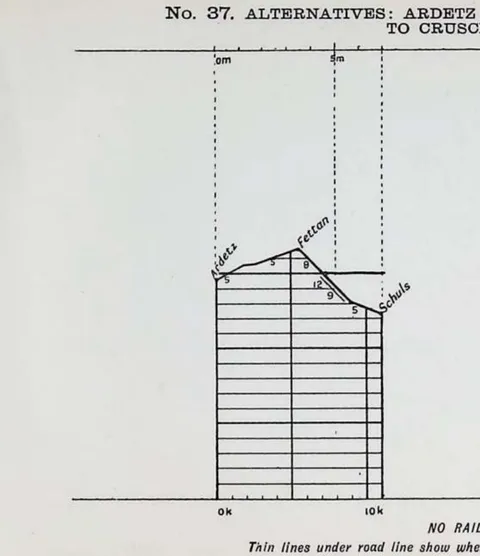 (opens in a new tab)
 No. 37. ARDETZ TO SCHULS. 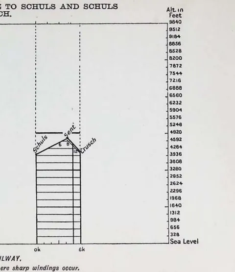 (opens in a new tab)
 No. 37. SCHULS TO CRUSCH. 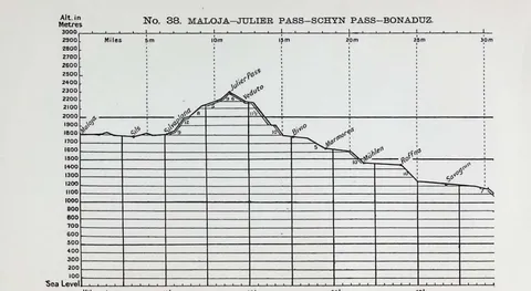 (opens in a new tab)
 No. 38. MALOJA…JULIER PASS…SCHYN PASS…BONADUZ. 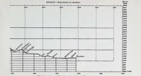 (opens in a new tab)
 RAILWAY.…Tiefenkastel to Bonaduz. 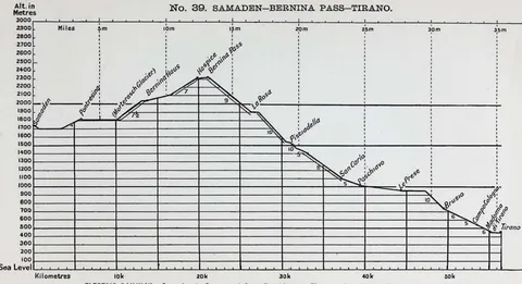 (opens in a new tab)
 No. 39. SAMADEN…BERNINA PASS…TIRANO. 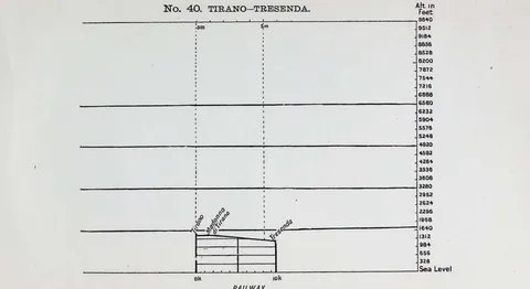 (opens in a new tab)
 No. 40. TIRANO…TRESENDA. 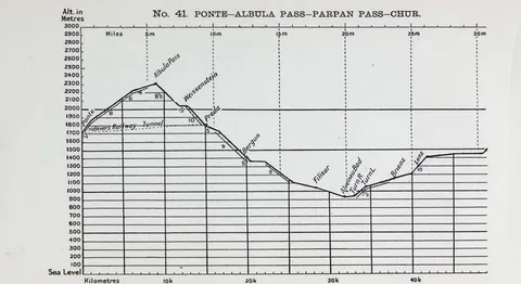 (opens in a new tab)
 No. 41. PONTE…ALBULA PASS…PARPAN PASS…CHUR. 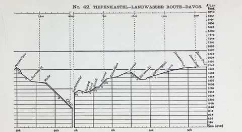 (opens in a new tab)
 No. 42. TIEFENKASTEL…LANDWASSER ROUTE…DAVOS. 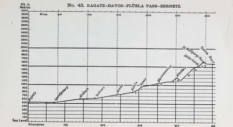 (opens in a new tab)
 No. 43. RAGATZ…DAVOS…FLÜELA PASS…ZERNETZ. 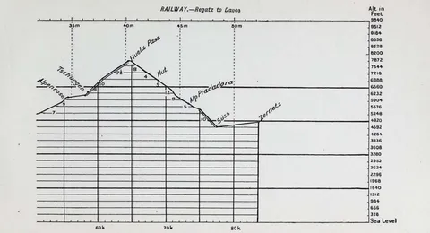 (opens in a new tab)
 RAILWAY.…Regatz to Davos 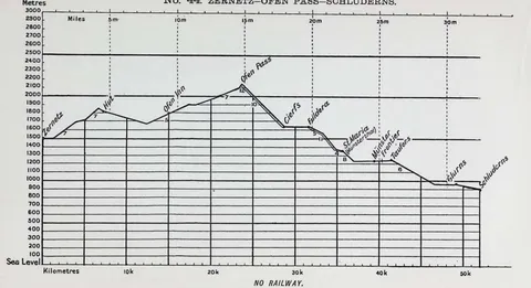 (opens in a new tab)
 No. 44. ZERNETZ…OPEN PASS…SCHLUDERNS. 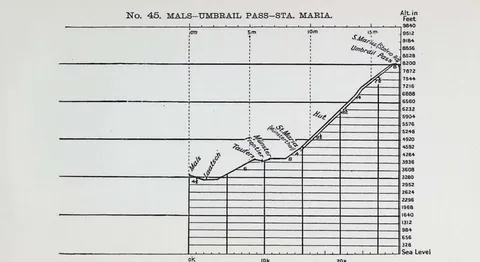 (opens in a new tab)
 No. 45. MALS…UMBREIL PASS…STA. MARIA. 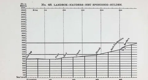 (opens in a new tab)
 No. 46. LANDECK…NAUDERS…NEU SPONDINIG…SULDEN. 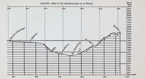 (opens in a new tab)
 RAILWAY.…Mals to Neu Spondinig (goes on to Meran). 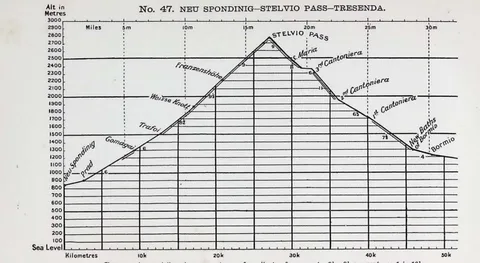 (opens in a new tab)
 No. 47. NEU SPONDINIG…STELVIO PASS…TRESENDA. 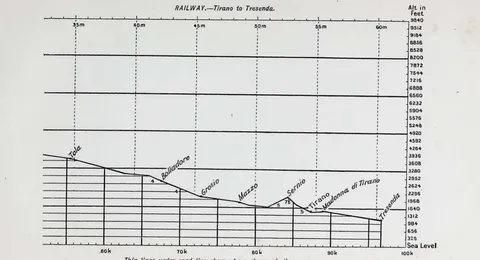 (opens in a new tab)
 RAILWAY.…Tirano to Tresenda. 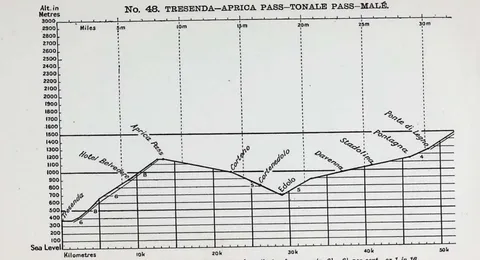 (opens in a new tab)
 No. 48. TRESENDA…APRICA PASS…TONALE PASS…MALË. 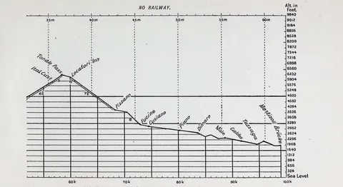 (opens in a new tab)
 NO RAILWAY. (continuation) 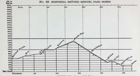 (opens in a new tab)
 No. 49. MOSTIZOLL BRÜCKE…MENDEL PASS…BOZEN. 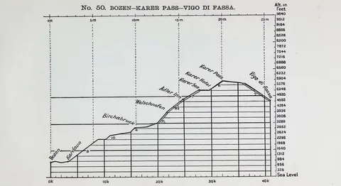 (opens in a new tab)
 No. 50. BOZEN…KAERER PASS…VIGO DI FASSA. 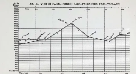 (opens in a new tab)
 No. 51. VIGO DI FASSA…FORDOI PASS…FALZAREGO PASS…TOBLACH. 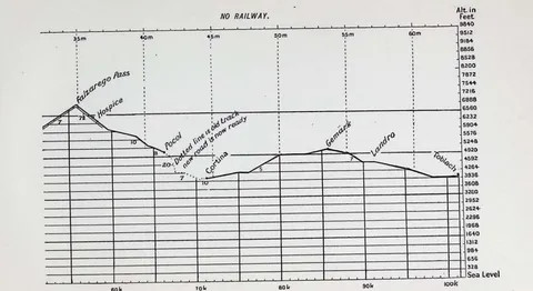 (opens in a new tab)
 NO RAILWAY. (continuation) 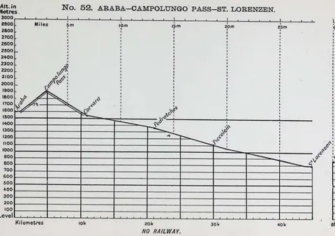 (opens in a new tab)
 No. 52. ARABA…CAMPOLUNGO PASS…ST. LORENZEN. 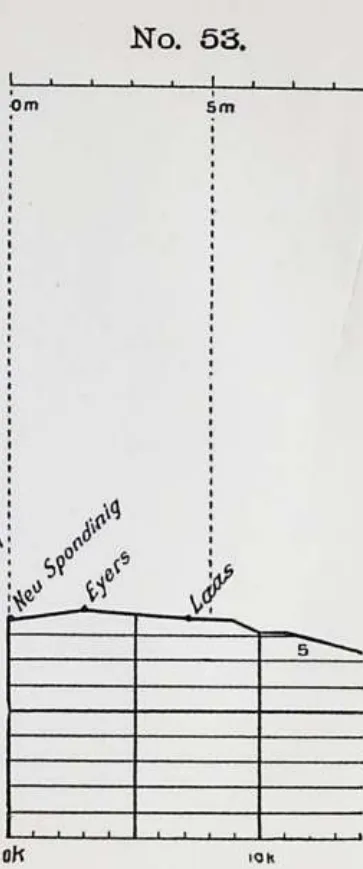 (opens in a new tab)
 No. 53. 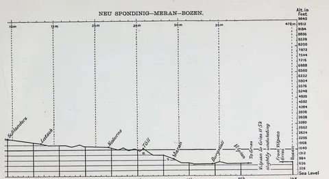 (opens in a new tab)
 NEU SPONDINIG…MERAN…BOZEN. 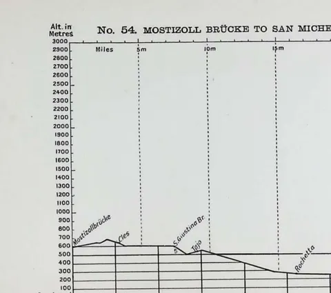 (opens in a new tab)
 No. 54. MOSTIZOLL BRÜCKE TO SAN MICHELE. 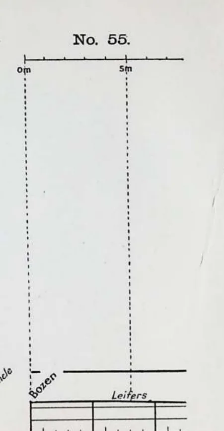 (opens in a new tab)
 No. 55. 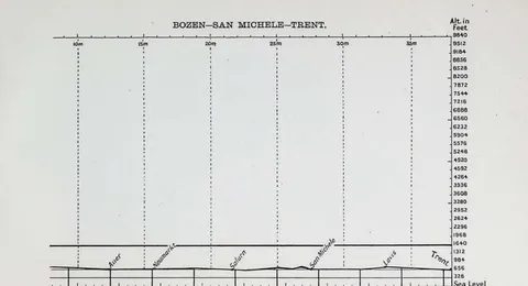 (opens in a new tab)
 BOZEN…SAN MICHELE…TRENT. 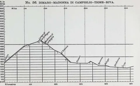 (opens in a new tab)
 No. 56. DIMARO-MADONNA DI CAMPIGLIO-TIONE-RIVA 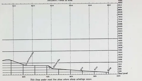 (opens in a new tab)
 RAILWAY.…Arco to Riva 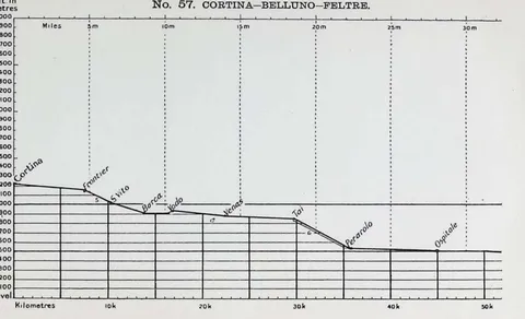 (opens in a new tab)
 No. 57. CORTINA-BELLUNO-FELTRE 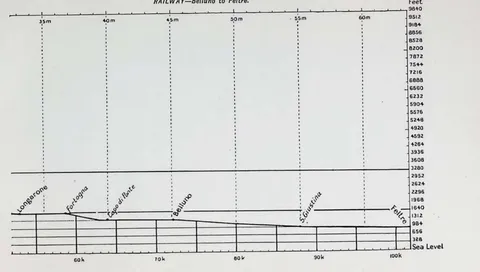 (opens in a new tab)
 RAILWAY.…Belluno to Feltre 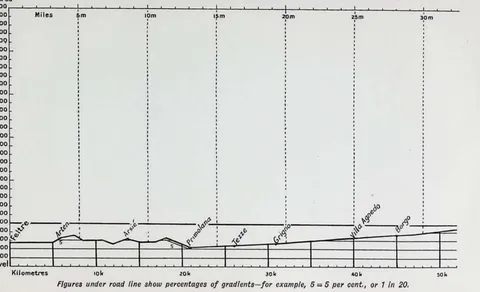 (opens in a new tab)
 No. 58. FELTRE-PRIMOLANO-LEVICO-TRENT-ALLESARCHE 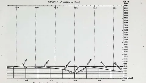 (opens in a new tab)
 RAILWAY.…Primolano to Trent 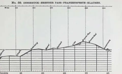 (opens in a new tab)
 No. 59. INNSBRÜCK-BRENNER PASS-FRANZENSFESTE-KLAUSEN 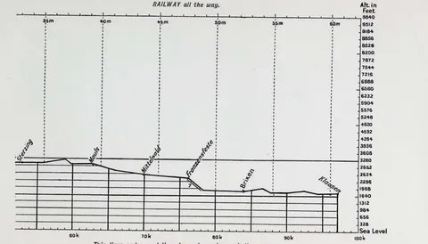 (opens in a new tab)
 RAILWAY all the way 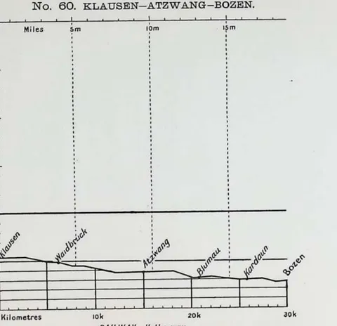 (opens in a new tab)
 No. 60. KLAUSEN-ATZWANG-BOZEN 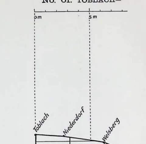 (opens in a new tab)
 No. 61. TOBLACH 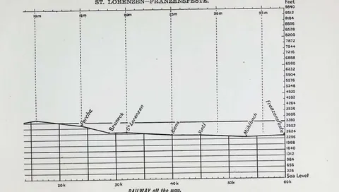 (opens in a new tab)
 ST. LORENZEN-FRANZENSFESTE 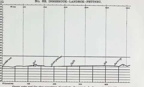 (opens in a new tab)
 No. 62. INNSBRÜCK-LANDECK-PETTNEU 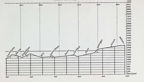 (opens in a new tab)
 RAILWAY all the way 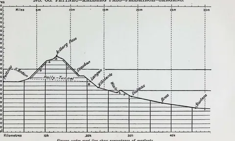 (opens in a new tab)
 No. 63. PETTNEU-ARLBERG PASS-FELDKIRCH-SARGANS 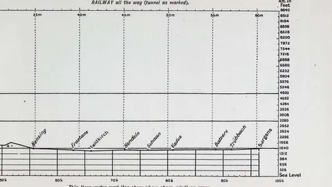 (opens in a new tab)
 RAILWAY all the way (tunnel as marked)